After leaving Island City, we carried on to Toppenish, Wa and pulled into the Legends Casino for a night. While here we signed up for the players club and received some coupons for the buffet and a $15 credit. The next morning we used those for the buffet and had a decent breakfast before heading to Monroe.
The trip to Monroe was pretty uneventful, even the climb up over Snoqualmie Pass was a non-event.
We are now at our friends, Chris and Jan Christensen's in Monroe, Wa for a few days. I've been helping with a few chores around here but it's been pretty laid back. Chris is a fellow modeller and we did get out for a few flights yesterday evening. Today, I believe there are plans to move a milling machine for another friend.
Tomorrow, we head back across the border and have plans to stop and visit friends in Mission.
Thursday, March 28, 2019
Sunday, March 24, 2019
Moving on and more snakes?
We had initially thought that the weather favoured staying in Ely (pronounced Eelie, BTW) another day or so, and Friday dawned kinda so-so but later on, things cleared up and warmed up so after doing our laundry, we decided to venture on. We pulled out about 1PM and made our way to Twin Falls in Idaho. Thankfully the drive was uneventful and we arrived about 5. One thing I had forgotten is that Twin Falls is right on the Snake River and just south of the massive Snake River Canyon.
We had figured we would stay at the Walmart in Jerome, just a few miles north of Twin Falls but as we were pulling off the freeway, we spotted a nice quiet looking spot that turned out to be the Jerome RV sani dump. It was mostly closed for the season so no traffic and a nice level spot to park which is what we did.
Last year while down south, we spent some time with some people who live in Twin Falls and have become friends. We had let them know we were coming through and had made arrangements to meet up at the info centre.
Eric and Susanne were kind enough to take us around and show us some of the local sights.
The info centre is right beside the Perrine Bridge which is the major crossing on US-93. It is also the only bridge in the US where BASE jumping is allowed. While we were here, we saw a couple of jumpers leap off the bridge and parachute to the ground down by the river.


Our first stop was the famous Shoshone falls. One interesting little tidbit; these falls were originally named the "Canadian Falls" by a Canadian priest in 1847. Sadly, the name didn't last and they were renamed the Great Shoshonie Falls in 1849. Some time later the name was shortened to Shoshone Falls.

After Shoshone Falls, they took us over to the falls the city was named after; Twin Falls.

There is only a single fall now as the second was blocked off and the water has been diverted through a hydro electric plant.
Next up was a place called Cauldron Linn. We had a little trouble finding it as the road isn't marked too well but Eric succeeded. When you think the entire flow of the Snake River flows through this 40 foot gap it's pretty impressive.


Finally they showed us the new house they are building at which time we headed back to the trailer. We had invited them over for dinner and Chris needed to get going on that. They arrived at 6:30 and we all had a nice meal and more socializing.
This morning turned out to be cold and wet but no indications of freezing or snow, so we headed out. We are now at a Walmart for the night in a town called Island City in Oregon.
Thursday, March 21, 2019
Summer to winter in 24 hours
Before I get too carried away, I promised a few more shots of the Valley of Fire.
These are some cabins built back in the 40's I believe, shortly after the park received its state park status.


Some interesting erosion patterns near the cabins.

One more shot of our camp site taken from on top of a big rock across the road.

And now on to today's entry.
It's amazing what 24 hours and a couple of hundred miles can do. It was so nice yesterday at Valley of Fire. We had a few light showers last night, and this morning, while there were some clouds around, started out as a decent day. We were packed up and ready to go around 10 AM or so. Because we didn't have any internet at camp, we stopped at a truck stop just after leaving the valley to figure out what our plan was. The initial plan was to head for Ely, Nv via 93 and 6 up the Great Basin Highway. After we had gone only a short distance, I got to thinking that the "Extraterrestrial Highway" would be an alternate that wouldn't take us too far out of our way. That route runs close to the famed "Area 51" which is the secret US Air Force proving ground that some believe is also the hiding place of a UFO that purportedly crashed at Roswell, NM. You can't see anything from the highway as it is on the other side of some hills but there is another attraction along the highway. The "Little A'Le'Inn" in the little town of Rachel, Nv is a roadside restaurant/pub/motel that plays on the Alien side of things.


We got here right around lunch time so decided to stop and have a bite. The pub looks like it had its heyday about 20 years ago. It is a bit run down now, and sells the usual tourist kitsch. We ordered burgers which were very so-so and a bit over priced. Unfortunately this place, for us anyway, was totally forgettable. The Extraterrestrial highway as well had to be one of the most boring 100 miles of road I can recall. Ah well, live and learn.
The western end of of the ET highway is a deserted little town called Warm Springs. Here we turned back northeastward and continued on to Ely. Part way along we could see a massive rainstorm ahead of us and even some lightning. Luckily it crossed our path and all we got was some showers and a very wet road for 10 miles or so. This stretch of highway is about 120 miles and crosses two fairly high passes. Just our luck, as we approach the first one at just under 7,000 feet, it started to snow! Just wet snow at first and not sticking to the road but as we approached the summit it was starting to stick and build up.

The road though still seemed OK. We took it slow and easy over that pass and made it through without too much fuss. 40 miles further on though was a different story. The second pass was even higher at 7,300 ft. and the snow got heavier and the build up on the road as well. The climb was fairly steep and all I could think of was "don't spin, don't spin"! I think that if we had, we would have been stuck. We crawled over the summit and took it real slow down the other side. The snow continued to fall heavily all the way into Ely.
We had planned to stop at the Hotel Nevada Casino for the night which we did. It continued to snow heavily for another couple of hours accumulating about 3 or 4 inches of wet snow.
This is the view out the side window from the hotels RV parking lot about 30 minutes before the snow stopped.

The forecast is for more snow for the next couple of days so we may be here for a bit. We will keep a close eye on the weather and won't venture out unless the roads look good. At least is is mostly down hill from here to our next planned stop in Twin Falls Idaho.
Wednesday, March 20, 2019
Valley of Fire
Well, we didn’t get rousted overnight in Vegas so I guess the place we parked couldn’t have been too bad. Monday morning, after breakfast and after saying our goodbyes to Larry and Val, we headed out. Our next stop was the Valley of Fire State Park. It is a short drive north of Vegas then about 15 miles east on quite a rough and windy paved road. The park has a campground but they operate on a first come, first served basis so we weren’t sure if there would be any sites available when we got there. We were hoping because it was Monday, some of the weekend warriors would be leaving and we would find a spot.
As it turned out, despite the “campground full” sign being out, there were a few spots. We found one to our liking and set up camp.

After lunch we went for a drive to see what was where and kind of get an idea of what we would do tomorrow.
This park is gorgeous! The rocks and formations here are just stunning. Most of rock formations in the park are red sandstone set down millions of years ago when this area was covered by an inland sea. After millions of years of erosion and tectonic activity, the landscape is as it is today. We did a bit of exploring, mostly in the truck but did see some interesting sights.
These are some of the formations around the visitors centre.

Peek a boo!


Just across from the campground are these petrified logs. These trees grew millions of years ago and after they died, the logs were buried under hundreds of feet of silt which eventually was compressed into stone. Minerals in solution slowly replaced the trees biological material and turned the logs into stone. They then eroded out and became visible again.

Tuesday, we headed back out after breakfast as there were a couple of hikes we wanted to do. About 7 or 8 miles from camp is a place they call White Domes. I think because the usually red sandstones here are more tan coloured and have been eroded into large, upright, roughly dome shaped formations. There is a loop trail that starts out descending quite steeply down to a wash that has cut a slot canyon through the rocks. It then gradually makes its way back around to the parking lot. All told about 1.25 miles and took about an hour or so.


This place, while the remotest part of the park, is also one of the few places where you can get a cell phone signal, so we also stopped for a few minutes and caught up on some emails.
After that was another slightly shorter hike to a place called Mouses Tank. A tank is a depression in the rocks that can sometimes contain water long after any rains. Mouse’s Tank is named for a Southern Paiute Indian renegade (“Little Mouse”) who used Valley of Fire as a hideout in the 1890’s after he was accused of killing two prospectors and other crimes in the area. This hike was about 3/4 mile or so and took about 45 minutes. I ventured a bit further and looped back, rejoining Chris and the main trail part way back.

After this we headed back to camp for lunch and just relaxed for the rest of the day.
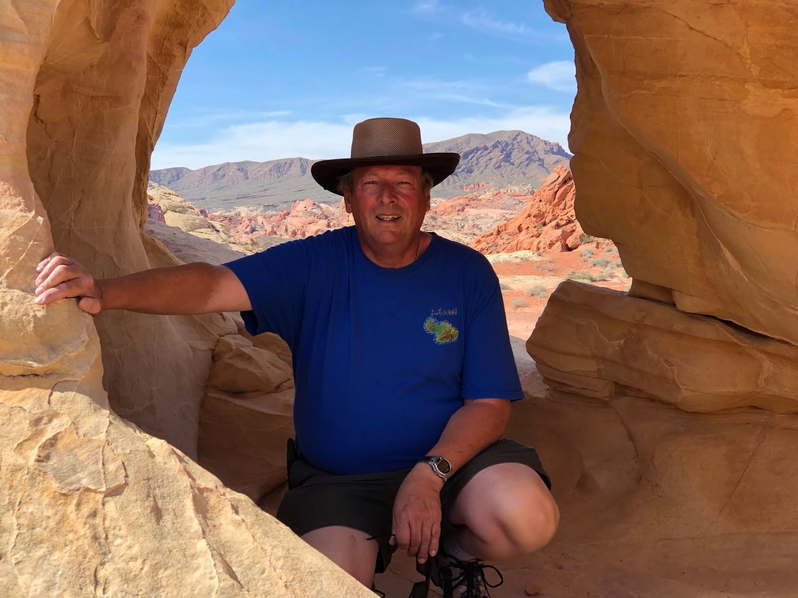
Today, I wanted to do one more hike but Chris decided against it so I headed out on my own. Turns out it was a bit more than I had expected. 4.5 miles with a fair bit of uphill and scrambling. It took me about 2 hours but was well worth it. It was to a feature called the Pinnacles.


Right at the top of the trail tucked into a hole in the rocks was this pack rat nest. No sign of the resident so I expect he was probably sound asleep in there somewhere.
I have a bunch more pictures, but to post this, we had to drive out of the park. We plan on pressing on tomorrow so I will probably post a bunch more once we get back out on the road and can get a decent internet signal.
As it turned out, despite the “campground full” sign being out, there were a few spots. We found one to our liking and set up camp.

After lunch we went for a drive to see what was where and kind of get an idea of what we would do tomorrow.
This park is gorgeous! The rocks and formations here are just stunning. Most of rock formations in the park are red sandstone set down millions of years ago when this area was covered by an inland sea. After millions of years of erosion and tectonic activity, the landscape is as it is today. We did a bit of exploring, mostly in the truck but did see some interesting sights.
These are some of the formations around the visitors centre.

Peek a boo!


Just across from the campground are these petrified logs. These trees grew millions of years ago and after they died, the logs were buried under hundreds of feet of silt which eventually was compressed into stone. Minerals in solution slowly replaced the trees biological material and turned the logs into stone. They then eroded out and became visible again.

Tuesday, we headed back out after breakfast as there were a couple of hikes we wanted to do. About 7 or 8 miles from camp is a place they call White Domes. I think because the usually red sandstones here are more tan coloured and have been eroded into large, upright, roughly dome shaped formations. There is a loop trail that starts out descending quite steeply down to a wash that has cut a slot canyon through the rocks. It then gradually makes its way back around to the parking lot. All told about 1.25 miles and took about an hour or so.


This place, while the remotest part of the park, is also one of the few places where you can get a cell phone signal, so we also stopped for a few minutes and caught up on some emails.
After that was another slightly shorter hike to a place called Mouses Tank. A tank is a depression in the rocks that can sometimes contain water long after any rains. Mouse’s Tank is named for a Southern Paiute Indian renegade (“Little Mouse”) who used Valley of Fire as a hideout in the 1890’s after he was accused of killing two prospectors and other crimes in the area. This hike was about 3/4 mile or so and took about 45 minutes. I ventured a bit further and looped back, rejoining Chris and the main trail part way back.

After this we headed back to camp for lunch and just relaxed for the rest of the day.
Today, I wanted to do one more hike but Chris decided against it so I headed out on my own. Turns out it was a bit more than I had expected. 4.5 miles with a fair bit of uphill and scrambling. It took me about 2 hours but was well worth it. It was to a feature called the Pinnacles.


Right at the top of the trail tucked into a hole in the rocks was this pack rat nest. No sign of the resident so I expect he was probably sound asleep in there somewhere.
I have a bunch more pictures, but to post this, we had to drive out of the park. We plan on pressing on tomorrow so I will probably post a bunch more once we get back out on the road and can get a decent internet signal.
Sunday, March 17, 2019
Asses and Dams
Friday morning we decided not to stick around Havasu and to carry on. One place Chris had wanted to visit was a little town called Oatman about an hour further north. The original plan was to leave the trailer in Havasu and do a day trip, but looking at the map we figured that rather than backtrack, lets just take the trailer with us. It turns out the road was a little rougher and more windy than I would have liked, but we all survived it.
Oatman is an old mining town that had its heyday in the late 19th and early part of the 20th century. Like a lot of places in the southwest, it owes its existence to gold.
Oatmans attraction now is its artistic population and the descendants of the original burros that were left to run wild after the gold ran out. While technically still wild, they hang around town looking for handouts from the hundreds of visitors that come through here every day.

There are signs all over the place warning people to keep their distance but these things are so tame! I hear that they will bite and kick if they get annoyed though so there are signs all over the place warning people to give them their space.


Lots of places in town sell little food pellets so you can feed them. Somehow I don't think these things go hungry!


While climbing up the hill from the valley floor, we could see patches of orange flowers off in the distance. Once we got closer, I was able to pull off and see that they are Poppies. I'm not sure if they are California Poppies or Mojave Poppies though. There were quite a few large patches of them all over the hills. What with all the rain this winter, there is a full bloom going on.


After finishing up in Oatman we decided to press on to our next planned stop which was Henderson. Chris had found that we could stay at the Railroad Pass Casino for a few nights, so that is what we did. This would also position us nicely for Saturdays planned activity which was the Hoover Dam.
I had been there once before way back in the late 70's but didn't really remember too much of it so I was looking forward to it.
There have been a few changes to the dam in how they manage visitors. They have built a big new parkade and ramped up security a lot. We had to have the truck inspected just to get down the hill and then had to personally go through an airport style security check to get into the visitor centre. We had signed up for the powerhouse tour, so before starting that we were shown a short video on the history of the dam then about 70 of us all trouped into the elevators and were taken way down to the powerhouse.

This is the Nevada side power house. There is another one almost the same on the Arizona side.

The tours were pretty quick and ended up in the interpretive centre. There were a number of interesting displays there that we got to see and play with.

This photo depicts the construction of the dam. After the tours were done, we walked across the dam and back then back to the truck. The plan was to drive across the dam then up and take the new bridge back to Henderson. Apparently they have stopped allowing through traffic as, after crossing the bridge and driving back up the hill, the road was blocked off, so we had to turn around and drive back across in the other direction.

After that, we went back to the casino. We had made arrangements with friends Larry and Val Patterson to meet for dinner. Just before dinner, Chris and I headed over to sign up for their player cards and one of the benefits of that was a 2 for 1 at the buffet. While we were doing that, Larry and Val arrived and Larry signed up as well. Saturday night was prime rib night so we all pigged out on dead cow then headed back to the trailer for a night cap.
Today, after another 2 for 1 buffet, brunch this time, we packed up and moved to a temporary spot in North Las Vegas just across the street from Larry and Vals place. It is supposed to be BLM land so I hope we don't get rousted in the middle of the night. They had invited us for supper which was delish. After supper they took us downtown to Freemont Street. Man was it crowded! It was St Paddy's day so it was a sea of green but according to Larry, it is packed down here every night. We wandered around for about an hour, saw the LED light show and visited a couple of the shops before we all decided we had had enough. One thing we all were noticing was the amount of smoke on the street; not just cigarette but weed as well. It is legal here and a lot of it was being consumed.


After that, they drove us down the strip before heading back.
All in all a very busy and satisfying day.
Thursday, March 14, 2019
Windy, windy, windy
Well, the rain continued through Monday night and well into Tuesday. Everything around us was quite wet and the usually dry washes were running again.

Everyone we have talked to who has spent any amount of time down here says they can't remember a year where the desert was this green at this time of year. Also the wild flowers are still in full bloom as well. You can't walk hardly anywhere without stepping on them. We didn't do much Tuesday as it was just too wet and cold.

The story of Wednesday had to be the wind! The good news is that the clouds cleared off and the sun came out but the wind really started to howl. It blew all day and right into the night. The trailer got rocked a few times by very strong gusts. From what I hear though, we had it easy compared to New Mexico a few hundred kilometres east. There it was strong enough to blow trains off bridges and tip over trucks on the highway!
Later in the day, Chris and I decided to make one last trip into Quartzsite more or less for something to do. Between last winter and this one, we have been into the town of Quartzite countless times. One thing we had not done until yesterday though was visit the Hi Jolly Monument. Hi Jolly was a camel herder who spent most of his life in the Southwest. The link above has lots of information on this interesting character. There is a monument to his life and exploits in the area at his gravesite in the Quartzsite cemetery.


Today (Thursday) was moving day again. We said our goodbyes and continued the slow trip home. Today was only a short drive up the road of just over an hour. We have moved to a BLM area just north of Lake Havasu City. The wind is still blowing as well. Maybe not quite as strong as yesterday, but still strong enough to shake the trailer occasionally. We expect to stay here for a day or 2 before carrying on. We visited the London Bridge last year when we were here so doubt we will do that again but will see what else there is to do here. There are some interesting rock formations in the area but I don't think I will try and climb any of them.


Monday, March 11, 2019
Stone arches and more rain
Shortly after arriving here a couple of days ago, I noticed a rock ridge across the road just to the North of us with what looked like a couple of stone arches.

I looked up the location of the ridge on Google Earth and found that it was only about a mile from where we were camped so would be an easy hike. So about 10AM on Sunday, I set off. Getting there only took about 25 minutes as I just cut straight across the desert. It started out as a coolish morning but was warming up quickly and with the warmth comes the possibility of snakes so I was keeping a close eye out to where I was stepping. Fortunately I didn't come across any but I did find lots of wild flowers though. Are you getting tired of flower pictures yet?

There were lots of this one which iNaturalist identifies as Nama or Purple Mat.
Carrying on, once I got to the bottom of the hill, the next challenge was figuring the best way up. Most of the hills around here are composed of loose rock over the substrate so can be pretty slippery if you aren't careful where you step. It took me another 15 minutes or so to make it up to where the arches were. It was worth the climb as they were quite impressive. A bit bigger than they looked from down below too! This one was big enough to walk through without bending over too much.


If you look carefully through this one, you can see our camp off in the distance.
I also discovered there was a geocache up here so took a few minutes to locate that as well. It proved a bit more difficult that I had thought as my GPS was leading me in circles on the wrong side of the hill. Perseverance paid off though as I did finally locate it.
I came down a slightly different route and took this shot about halfway down near another rock outcrop.


From the same spot as the last shot, I took this one looking back towards our camp. You can just see it to the right of the Saguaro cactus.
I went looking for another couple of geocaches on the way back and made it to the trailer just around 12.
Today there were plans for lunch trips into the local towns. The guys were heading in to a pizza place in Quartzsite while the gals were going Mexican in Parker. I didn't sleep all that great overnight and wasn't feeling all that great so elected to stay behind, but I gather a good time was had by all.
Around about 3:30 it has started to rain again! The forecast shows showers through most of the night tonight and then mainly cloudy tomorrow. I hope we get back to nicer weather soon. I am getting tired of the rain. Oh well, at least I don't have to shovel it!
Subscribe to:
Posts (Atom)